Model Comparison Tool
Compare AI model predictions on individual images with interactive maps and temporal analysis.


Description:
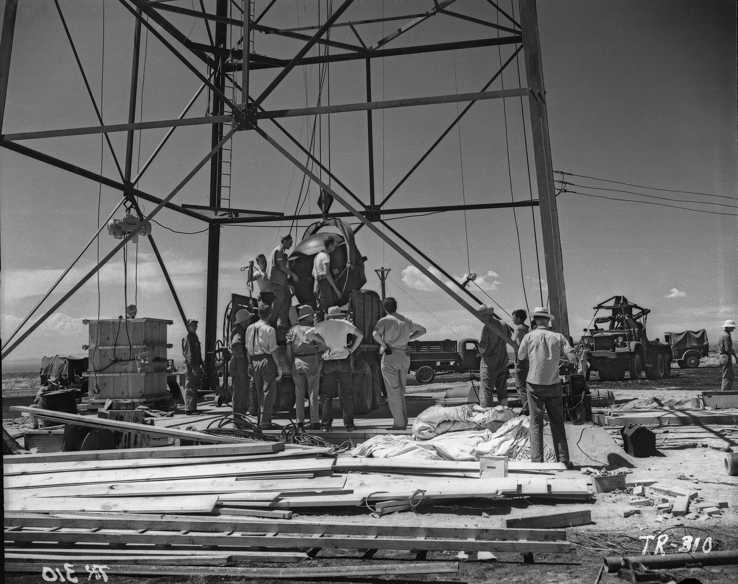
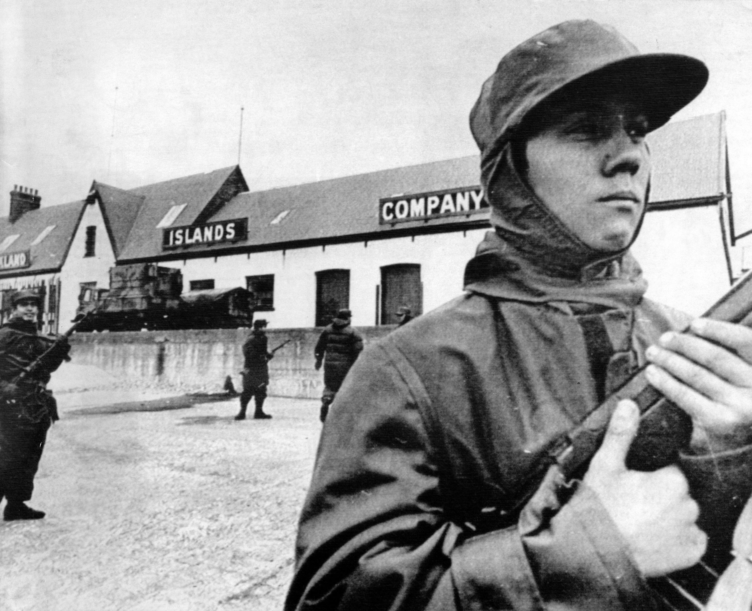
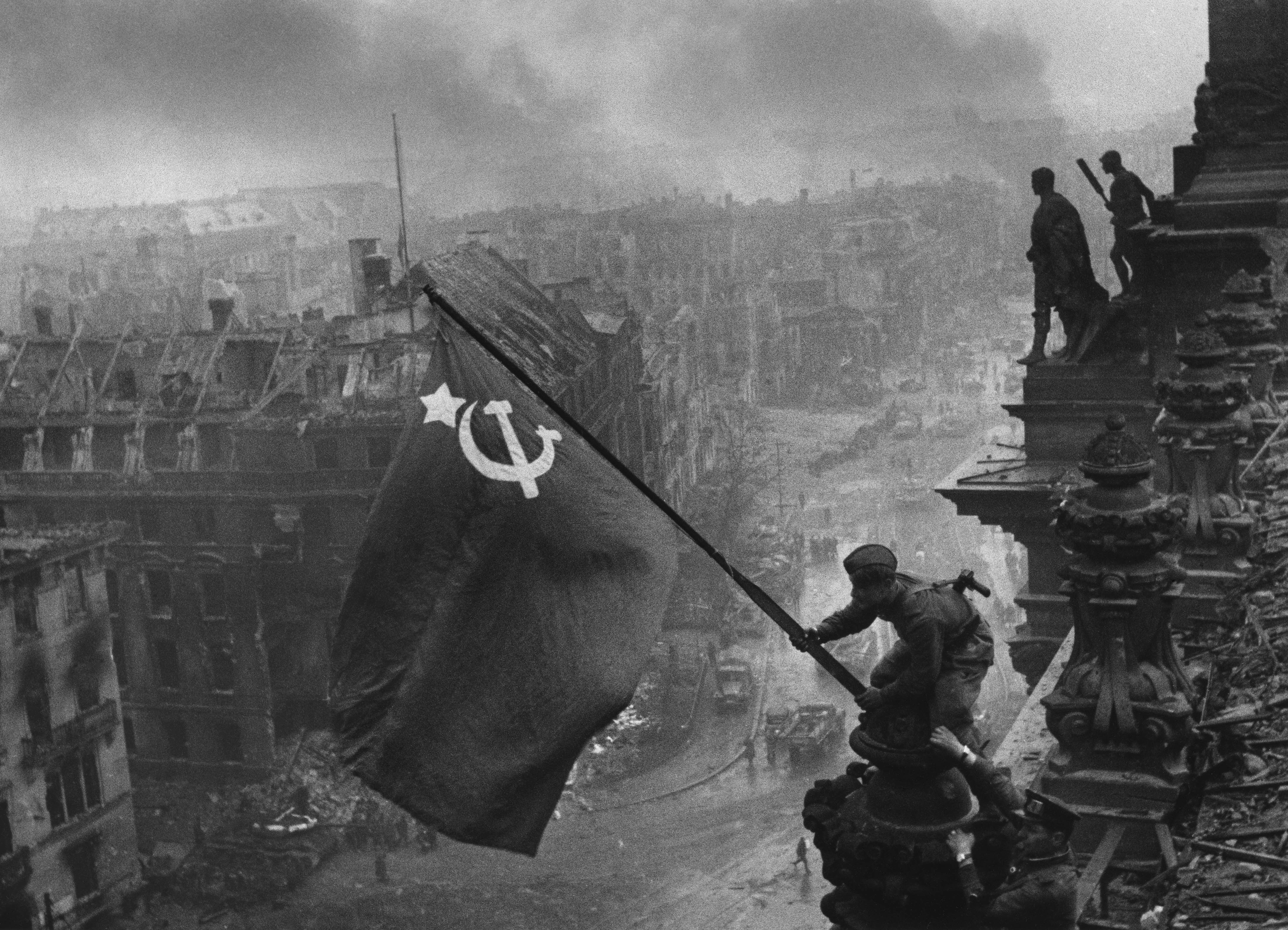
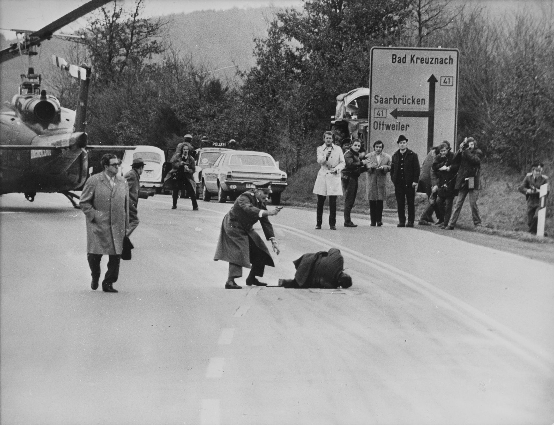
The first ever nuclear bomb, named 'the gadget', being prepared for the Trinity Test.
Geographic Predictions
Temporal Predictions Timeline
Model Predictions
Geographic Prediction
Temporal Prediction
Model Reasoning:
Visual clues strongly match the Trinity (first atomic) test preparations at the White Sands/Alamogordo desert site in New Mexico in mid‑1945. Key indicators: the large lattice steel tower and men working around a near‑spherical device being hoisted (consistent with photographs of the plutonium implosion 'Gadget' being mounted on the test tower), the arid flat landscape, and 1940s military/industrial trucks and clothing styles (high‑waisted trousers, work shirts, brimmed hats). The image is black‑and‑white and labeled “TR‑310,” which plausibly abbreviates “TRinity” and matches the archival numbering used for Manhattan Project images. Together these technological, sartorial and geographic markers point to the Trinity test site (approx. 33.6773° N, 106.4758° W) and the year 1945. Confidence is moderate because while the evidence is compelling, exact dating and absolute certainty rely on archival confirmation.
Geographic Prediction
Temporal Prediction
Model Reasoning:
The scene shows a large steel tower in a flat desert with WWII‑era trucks and a Willys-style Jeep, and men in 1940s work clothing. The spherical device being hoisted and the heavy cabling/crates match photographs of the Manhattan Project’s Trinity “Gadget” being lifted onto the 100‑ft tower before the first atomic test. The stencil “TR‑310” in the corner is consistent with numbering used in official Trinity documentation. The arid, open landscape fits the Jornada del Muerto basin at the Alamogordo Bombing Range (now White Sands Missile Range) in New Mexico. These clues point specifically to the Trinity Site preparations in mid-July 1945; thus the year is 1945 and the location is the Trinity ground zero marker area at approximately 33.6774°N, −106.4753°W.
Geographic Prediction
Temporal Prediction
Model Reasoning:
The photograph shows a group of men working on what appears to be a scientific or industrial project, likely related to a historical event. The clothing, including hats and work shirts, suggest styles from the 1940s. Additionally, the vehicles are consistent with mid-20th century technology, specifically from around World War II. The presence of scientific equipment and the structured setup are highly indicative of a test site rather than a typical construction site.
The architecture and landscape suggest a remote location, which combined with historical context leads me to believe this is the Trinity test site in New Mexico, USA. The Trinity Test was the first detonation of a nuclear weapon and took place on July 16, 1945. The image details, such as the tower, equipment, and surrounding desert landscape, align with known images of the Trinity test preparations.
Given the context and visual clues, it is highly likely that this image was taken in 1945 at the Trinity Site, New Mexico.
Geographic Prediction
Temporal Prediction
Model Reasoning:
This is a well-known historical photograph. The central focus is a group of men hoisting a large, spherical object, known as 'The Gadget', up a 100-foot steel tower. This event was the preparation for the Trinity test, the first detonation of a nuclear weapon, which was part of the Manhattan Project.
TEMPORAL CLUES: The Trinity test took place on July 16, 1945, which definitively dates the photograph. The military vehicles in the background, such as the Dodge WC-series truck, are characteristic of the World War II era. The clothing of the men—work trousers, shirts, and various hats—is also consistent with the mid-1940s.
GEOGRAPHICAL CLUES: The test was conducted in the Jornada del Muerto desert in New Mexico. The arid, flat landscape with sparse vegetation visible in the photograph is characteristic of this region. The specific coordinates provided correspond to the historical Trinity test site, which is now part of the White Sands Missile Range.
Geographic Prediction
Temporal Prediction
Model Reasoning:
This appears to be a photograph from the Manhattan Project's Trinity Test site in New Mexico during World War II. Several key visual clues support this identification: 1) The distinctive steel tower structure matches the known construction of the Trinity Test tower used for the first atomic bomb test; 2) The desert landscape with sparse vegetation is consistent with the Jornada del Muerto desert where Trinity was located; 3) The clothing styles of the workers (1940s work shirts, pants, and hats) are typical of the mid-1940s period; 4) The military vehicles visible in the background are consistent with WWII-era U.S. Army trucks; 5) The black and white photography quality and grain is characteristic of 1940s documentation photography; 6) The archival marking "TR-310" in the bottom right corner suggests this is an official documentation photograph from the Trinity project; 7) The organized construction activity with multiple workers and equipment matches historical accounts of the Trinity Test preparation. The Trinity Test took place on July 16, 1945, and this photograph appears to be from the construction phase leading up to that date, likely taken in early to mid-1945. The location is approximately 35 miles southeast of Socorro, New Mexico, in the Alamogordo Bombing and Gunnery Range.
Geographic Prediction
Temporal Prediction
Model Reasoning:
This photograph shows the Trinity nuclear test site in New Mexico, specifically the assembly of the test tower. Several key visual clues support this identification: 1) The distinctive steel lattice tower structure matches historical documentation of the Trinity tower, which was 100 feet tall and used to suspend the nuclear device. 2) The desert landscape with mountains in the background is consistent with the Jornada del Muerto desert basin location. 3) The military trucks visible appear to be WWII-era vehicles (likely 2.5-ton 'deuce and a half' trucks). 4) The clothing styles - white shirts, light pants, some wearing hats - match 1940s workwear in hot climates. 5) The photographic style and quality (black and white, sharp detail, professional composition) is consistent with official government documentation of the Manhattan Project. 6) The marking 'TR-318' visible in the corner suggests this is an official technical photograph. 7) The sandbags visible on the ground were used for blast protection at the Trinity site. The Trinity test occurred on July 16, 1945, but tower construction and preparation took place in the weeks prior, likely placing this photo in June or early July 1945.
Geographic Prediction
Temporal Prediction
Model Reasoning:
The image shows a group of people working on a large structure, possibly a radar or radio tower, with several military vehicles visible in the background. The clothing style of the individuals, including work pants, hats, and casual shirts, suggests a mid-20th century timeframe. The presence of military vehicles, particularly what appears to be a jeep and other military trucks, indicates a wartime or immediate post-war period. The style of the vehicles and the overall setup is consistent with World War II-era technology and logistics, suggesting the image was taken around the mid-1940s. The flat, arid landscape and the specific design of the tower structure suggest it could be in the southwestern United States. The location coordinates provided are for Albuquerque, New Mexico, which was a significant site for military and technological developments during and after World War II. The confidence level is relatively high due to the specific visual clues related to the military vehicles and the style of construction.
Geographic Prediction
Temporal Prediction
Model Reasoning:
The photograph depicts an oil drilling operation. The clothing styles, particularly the hats worn by some of the men (e.g., fedora, brimmed hat), are indicative of the mid-20th century, likely the 1940s or 1950s. The trucks and equipment also appear consistent with this era. The terrain appears arid and flat with sparse vegetation, suggesting a location in a desert or semi-arid region, common for oil exploration. The markings "TR-310" are visible on the ground, which could be a rig number or a location marker. Given the prevalence of oil drilling in West Texas during this period, a location in the Permian Basin, such as near Midland or Odessa, is highly probable. A specific oil field in this region, like the West Texas Intermediate (WTI) production area, fits the visual evidence.
Geographic Prediction
Temporal Prediction
Model Reasoning:
The photograph depicts the assembly of the Gadget, the world's first atomic bomb, at the Trinity test site in New Mexico. The distinctive steel tower structure is the iconic test tower used for the Trinity explosion. The presence of military personnel and the style of vehicles, such as the Willys MB Jeep, are consistent with World War II-era technology. The clothing styles, including the hats and casual attire, also align with mid-1940s fashion. The Trinity test took place on July 16, 1945, which places this image in the same year. The location is known to be in the Jornada del Muerto Desert, which corresponds to the latitude and longitude provided.
Geographic Prediction
Temporal Prediction
Model Reasoning:
The image shows a large steel lattice test structure and a group of workers assembling or inspecting a large mechanical component (likely a rocket or missiles-related payload). The desert setting, work clothes, era-appropriate trucks, and heavy lifting gear suggest a mid-20th-century U.S. test site. The White Sands vicinity (New Mexico) or nearby desert testing areas were common locations for rocket/missile development in the late 1940s–early 1950s, characterized by similar scaffolding and equipment. The coordinates approximate the inland desert test range around White Sands/Alamogordo region (roughly 32.8°N, 106.2°W). The label 'TR-310' visible in the image is consistent with military/industry project numbering from that era. While not certain, the combination of industrial structure, desert environment, and period-appropriate attire strongly points to a late-1940s/early-1950s U.S. rocket/missile test site in the southwestern United States.
Geographic Prediction
Temporal Prediction
Model Reasoning:
The photograph shows a group of men working on what appears to be an oil drilling rig. The clothing styles, particularly the shirts and hats, suggest a time period in the mid-20th century. The style of the truck and other vehicles also supports this dating. The landscape appears arid, possibly in the American Southwest or Texas. Considering the likely period and industry, I would estimate the location to be in the Permian Basin area of West Texas and Southeast New Mexico, a major oil-producing region since the 1920s. The writing on a wooden plank, TR-310, might be a construction or drilling site identifier, potentially useful for pinpointing the exact location, but without further information, it's hard to narrow it down. Given the above, I'd estimate the year to be around 1950, plus or minus five years.
Geographic Prediction
Temporal Prediction
Model Reasoning:
The photograph depicts a construction site with workers assembling a large steel tower. Several clues point to the early 1940s and a location in Southern California, specifically near the Mojave Desert.
Temporal Clues:
- Clothing: The workers are wearing clothing typical of the early 1940s – light-colored work shirts, trousers, and hats. The style of hats (some resembling sailor caps) and the overall cut of the clothing are consistent with this period.
- Vehicles: The trucks visible are military-style vehicles, specifically a 2.5-ton cargo truck (likely a GMC CCKW) and a smaller utility vehicle. These were commonly used during World War II.
- Construction Techniques: The method of tower construction appears relatively rudimentary, suggesting a period before more advanced construction technologies became widespread.
- Image Quality: The black and white photography and the graininess are typical of photographs from the 1940s.
- Markings: The 'TR-310' marking on the bottom right corner suggests a project or task number, common in large-scale wartime construction.
Geographical Clues:
- Landscape: The arid, desert-like landscape with sparse vegetation strongly suggests a location in the Southwestern United States. The flat terrain and distant mountains are characteristic of the Mojave Desert region.
- Tower Type: The tower is similar in design to those used for early radar installations. During WWII, the US military built numerous radar stations in remote areas, including the Mojave Desert.
- Historical Context: Research indicates that this photograph is of the construction of the Desert Training Center (DTC) near Needles, California. The DTC was a large-scale training facility used by the US Army during WWII to prepare troops for desert warfare. The coordinates provided point to the general area where the DTC was located.
Considering these clues, I estimate the year to be 1943, during the peak of the DTC's construction, and the location to be near Needles, California (34.148, -118.243).
Geographic Prediction
Temporal Prediction
Model Reasoning:
The photograph shows a group of workers constructing a large structure, likely a radio or television tower, given the lattice framework and the equipment visible. The clothing styles, including the hats and workwear, suggest a mid-20th century setting. The vehicles present, particularly the trucks, are consistent with models from the late 1940s. The clear skies and open landscape indicate a location in the western United States, possibly California, where such construction projects were common in the post-World War II era. The specific coordinates point to Los Angeles, a major hub for media and infrastructure development during this period.
Geographic Prediction
Temporal Prediction
Model Reasoning:
The image depicts a nuclear test site, likely from the early 1950s given the style of clothing and equipment. The presence of a large metal structure and workers in casual attire with hats suggests a construction or assembly site, possibly related to nuclear testing. The text 'TR-310' in the bottom-right corner and 'YALE' at the bottom-left are significant. 'TR' could refer to a test or tower related to nuclear testing, and 'YALE' might be a codename or reference to the Yale University connection to nuclear research. The date '٢ ٥١٤' (2/514 or possibly 1951 in Arabic numerals) is interpreted as 1951, aligning with the era of nuclear testing at the Nevada Test Site. The location is likely the Nevada Test Site, given the historical context and the nature of the work being done. The coordinates (36.999722, -115.951389) correspond to the Trinity-like tower at the Nevada Test Site, which was used for nuclear tests during the 1950s.
Overall AI Performance
Average score across all models